About this project
Tourism in Hamburg has been substantially and continuously growing during the last decade. The city has reached position ten among the most popular European city destinations last year with more than 10 million overnight stays. And still further tourist attractions like the new concert hall ‘Elbphilharmonie‘, two additional musical theatre venues and even a cable car over the river Elbe are projected or under construction. At the same time loads of new hotels are opening in almost any location close to the city center.
But (at least as far as I know) there is no big picture that documents the spatial distribution of tourists in Hamburg at this time. As well as there is no ‘masterplan’ for regulating the further growth in toursim that most likely is going to come. This marks the starting point for the mapping tourism project. It’s goal is to provide easily accessible information about the spatial dimension of tourism in Hamburg.
Interactive Map – Hotels in Hamburg
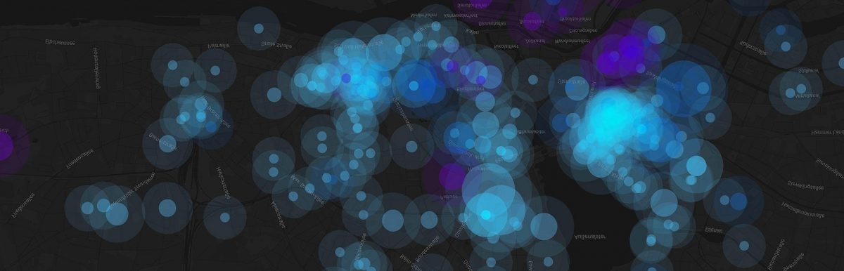
This map visualizes the location of all hotels and hostels inside of Hamburg’s city limits. The size of the circles correlates with the number of rooms per hotel and the color indicates the age of a hotel. Buildings which are older than five years are marked in light blue, those which were build within the last five years are shown in dark blue and the ones which are currently planned or under construction are colored in purple. The data for this visualization mainly comes from the free, crowd-sourced database hotelsbase with some additions from various hotel and hotel booking websites and Hamburg travel. The visualization itself is realized with CartoDB .
Findings
It’s pretty obvious and not very surprising that most of the hotels in Hamburg are situated close to the city centre. The highest concentration can be found just east of central station, where there are not less than 50 hotels (!) within a radius of around 250 meters. Taking a closer look at the current building dynamics we can identify two areas at the southern tip of the city centre where the density of hotel projects is remarkably high. First there ist Hamburgs currently biggest urban planning project, the ‘HafenCity’. A large scale brownfield redevelopment which, at least in it’s western and central parts, has already become a tourism hot-spot. Second, and that’s more surprising, there is the business district Hammerbrook. Surprising because at least until some years ago there haven’t been any other uses than offices. Still there’s really nothing to explore for tourists in this area, but it’s close to the centre and real estate prices are relatively cheap.
While this map enables the viewer to get an impression of the spatial dimension of tourism at a glance, it doesn’t include information about the population and therefor can’t sufficiently answer the question how ‘touristy’ an area is. But another visualization can. The following, second map shows the ratio between inhabitants and tourists on a fine-grained level. The number of inhabitants is derived from a publication by the city of Hamburg. The number of tourists per area is added by spatially joining the number of hotel rooms for each map feature. It’s easy to see which are the most touristy parts of town (marked in blue). You can explore the map on your own and click on each area to find out the number of tourists and inhabitants staying / living there.
Interactive Map – Hamburg’s most ‘touristy areas’
Update 1: There’s more than only hotels & hostels
So far, our mapping tourism project visualized the spatial patterns of tourism in Hamburg by showing all hotels & hostels. But even when we only look at the places where tourists stay, this view is incomplete. Holiday rental accommodations and camp sites for example could also be considered – and of course there are online marketplaces / community platforms like airbnb. They bring together hosts and guests and thereby offer a completely new way to explore a destination. Having stayed in great airbnb apartments in Switzerland and China, meeting wonderful people, I’m personally a big fan of this concept.
At the same time the hotel business is not amused about their new competitor. Whereas around 1,000 accommodations with a capacity of approx. 2,500 beds is a quite moderate number compared to more than 50,000 hotel beds in Hamburg, the situation in other cities (e.g. Barcelona with more than 11,000 airbnb listings) is different.
But how about the spatial distribution of those accommodations? Are there similarities to the patterns of hotel locations or do airbnb listings show different agglomerations?
To explore these questions we’ve collected location data for every airbnb accommodation in Hamburg and visualized it on an interactive map, using cartoDB once again. We’ve slightly modified the style of our hotel map and used different colors and another basemap this time (mainly because we really love the stamen toner map). Of course this relatively abstract kind of visualization, using effects like transparency and overlay, doesn’t produce a very clean look, but it might help to identify patterns. Take a look and explore the airbnb hotspots in Hamburg here: (for full screen click here)
Interactive Map
But how about the direct comparison: patterns of hotels vs. pattern of airbnb accommodations?
Let’s take a closer look (this time working with the same map style in both cases) at Hamburg’s most touristy areas.
- The Reeperbahn (bottom centre of the image) is Hamburg’s famous amusement district. It offers a wide range of bars & clubs, hosts the red light district and seems to offer a concentration of hotels as well as airbnb accommodations.
- Totally different is the situation at Sternschanze (top centre of the image, use the arrows to change between the two images). The close-by neighborhood is a residential area which in recent years more and more developed into a tourist destination with a huge variety of bars, restaurants and fashion stores. While there are hardly any hotels to be found, there’s a strong agglomeration of airbnb accommodations.
In our opinion this distribution can be explained by the following:
- Sternschanze is Hamburg’s ‘hipster district’. It’s only logic that we see the highest agglomeration of airbnb listings in an area that’s especially popular with young people that frequently use social networks and the like.
- A system like airbnb can easily adopt to changing preferences of tourists (to be more precise, it’s of course not airbnb itself that acts, but the collectivity of apartment host). Providers like airbnb thus benefit from an accommodation demand gap in quarters with limited space for new building projects whereas tourists benefit from the adaptability of these platforms.