Since today, mappable is not a one man project any more. As it is quite hard to find enough time for pushing it forward next to working full-time, I’m really happy to now join forces with my friend and colleague Achim. For more information about us and our goals at mappable see our updated about page. And the best thing is: we’ve already begun working on a really neat new project. More information will follow soon.
The future of subway station area maps
During a trip to Asia a few weeks ago I had the pleasure to spend some days in Seoul, South Korea. Even tough I knew that Korea is a very high-tech society, I was still amazed by the extend to which e.g. location based services are integrated into everyday life and used by people of all ages.
Especially an interactive, map centered information device, named ‘Digital View’, impressed me. Built around a huge 46“ touchscreen and operated by the popular Korean web portal Daum, these terminals offer probably any kind of information about the surrounding area you’ll ever need. Here’s a list of some of the available features:
- information about news, weather, finance, etc.
- entertainment services
- ticketing, e.g. purchasing movie tickets
- maps with diverse styles (road, satellite, hybrid, google Street View-like) and different layers with points of interests (shopping, accommodation, banks, real estate)
- free phone calls
- real-time bus schedules, subway maps and direction details
Features that make them extremely helpful for finding the fastest way through Seoul’s massive underground transportation network as well as for getting all the required information about the surrounding area.
 Just for the record: here in Hamburg (and I don’t think the situation in other big German cities is different) we still rely on badly readable poster maps, showing nothing but a road-map of the surrounding and I don’t see anything comparable to Seoul’s Digital View popping up here in the coming years. Considering that the installation in Seoul began in 2010, we are already, in terms of technology, lacking behind five to ten years.
For more details, see:
https://en.wikipedia.org/wiki/Seoul_Metropolitan_Subway
http://www.daumcorp.com/DaumEng/about/service.daum#viewd_10http://english.chosun.com/site/data/html_dir/2010/02/19/2010021900782.htmlhttp://www.advancedtechnologykorea.com/303
http://www.advancedtechnologykorea.com/303
http://english.chosun.com/site/data/html_dir/2010/02/19/2010021900782.html
similar system in NYC coming up: http://cityroom.blogs.nytimes.com/2013/04/08/new-screens-in-the-subway-will-guide-riders-and-sell-to-them-too/
Mapping the growth of tourism in Hamburg
Tourism in Hamburg has been substantially and continuously growing during the last decade. The city has reached position ten among the most popular European city destinations last year with more than 10 million overnight stays.
Even tough the topic of tourism growth is drawing increasing public attention, especially when it comes to spectacular projects like the new concert hall ‘Elbphilharmonie‘ or the plans to build a cable car over the river Elbe, I’ve never come across a good visualization on that issue. Which, at least in my eyes, is quite astonishing, as most of the underlying information like hotel addresses or tourist attractions is space-related.
This is where I got started with my just for fun side project. I collected data of hotel locations, categories, years of construction and number of rooms from the free, crowd-sourced database hotelsbase. After quite a lot of data wrangling and searching further details from various hotel- and hotel-booking websites, the only thing missing was information about current building projects. Fortunately there is an up-to-date overview of hotel projects provided by Hamburg travel.
Finally, the fun part about the whole thing was visualizing the collected information by using CartoDB. A really powerful, yet easy to use web-based mapping platform. A big recommendation, even for those of you who are not too familiar with mapping. I started by showing the hotel locations on a dark base-map. In order to visualize the different hotel sizes and years of construction I made further adjustments to the default map style. As a result it is now quite easy to recognize which hotels were built in the last five years (marked in dark blue) and which are currently planned or under construction (purple).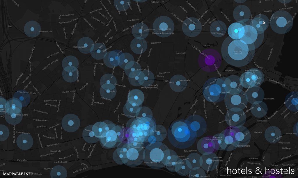
You can explore the final and fully interactive map here. Furthermore there is a more in depth analysis of the identified patterns and some additional interpretation (unfortunately only in German). I’m quite curious how people will react to this relatively abstract, but spatial perspective on tourism growth in Hamburg.
Hello world
Welcome to my new website & blog.
I’ve always been deeply fascinated by all kinds of maps. Informative maps, beautifully designed maps, analytic maps, unusual ones…
I guess it’s the abstraction of the real, very complex, world into a simple and easily understandable visual representation that has always fascinated me. Being an urban planer / researcher I deal with maps on a regular basis. However, only in the last months it became clear to me how huge the potential of web-based mapping is. There are already so many innovative and mostly interactive maps and applications on the web, that show what can be done with the huge amount of data we’ve got nowadays. WOW, how could I have missed that for such a long time?
Anyway, now I’m just in the middle of exploring what’s out there, learning the necessary tools and of course making maps. Why? because it’s fun!
And what’s the blog for? Well, I’ll write about interesting stuff I stumble across and the hopefully numerous personal projects that are still to come.
Enjoy.